


23- Lac St Marguerite (partiel)

d.rochas
User
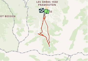

Length
11.5 km

Max alt
2228 m

Uphill gradient
742 m
Km-Effort
21 km

Min alt
1660 m

Downhill gradient
686 m
Boucle
No
Creation date :
2023-05-07 07:22:33.012
Updated on :
2023-05-07 17:02:29.089
7h20
Difficulty : Medium

FREE GPS app for hiking
 SityTrail
IGN / Geographical institutes
SityTrail Plus
The world is yours!
About
Trail Walking of 11.5 km to be discovered at Provence-Alpes-Côte d'Azur, Hautes-Alpes, Les Orres. This trail is proposed by d.rochas.
Description
Départ Les Orres 1650
Montée jusqu'au lac
Retour LesOrres 1800.
Dans la Neige !
Positioning
Country:
France
Region :
Provence-Alpes-Côte d'Azur
Department/Province :
Hautes-Alpes
Municipality :
Les Orres
Location:
Unknown
Start:(Dec)
Start:(UTM)
305192 ; 4928600 (32T) N.
Comments